
Interactive Bulletin Board United States Map Activity


- Zip
- Easel Assessment
What educators are saying
Also included in
 If you would like your students to learn the US states, this what you need!Included here is:United States Digital Map-Making Activity—drag and drop the states onto the U.S. MapUnited States Interactive Bulletin Board Geography Activity—construct a gorgeous GIANT United States map on your bulletin boPrice $26.99Original Price $32.46Save $5.47
Description
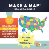
Transform your classroom into a vibrant learning space with this Interactive Bulletin Board United States Map Activity. This engaging project invites students to actively participate in constructing a colossal wall map of the USA, fostering a collaborative and hands-on approach to learning United States geography. Assign each student a state and watch as the United States comes together, state by state, on your bulletin board! The finished map is an impressive 73 inches in length and 55 inches in height, providing a visually stunning addition to your classroom.
This interactive bulletin board is more than just a decorative element! It serves as a dynamic tool for various educational purposes. Ideal for geography lessons, studying biomes, delving into U.S. history in social studies classes, as a Valentine's Day map, to explore states and capitals, or even for creating a pen pal map, this resource offers versatility in its applications. Coming up with new bulletin board ideas will be easy with this resource!
Step-by-step lesson instructions accompanied by illustrations make the assembly process seamless and enjoyable. The resource provides four customizable versions, allowing you to tailor the map to your specific needs. Choose from colored states with a fun font, colored but blank states for labeling and decorating, outlined states with printed names, or completely blank outlines for an open-ended creative exploration.
As a bonus, this resource now includes a self-checking EASEL Exit Ticket assessment with 6 multiple-choice questions, offering a digital component for assessment. This feature can be digitally assigned via various Learning Management Systems, including Google Classroom™, providing an additional layer of interactivity to your classroom experience. Audio is included so students can listen.
Elevate your bulletin board with an interactive United States map that not only enhances geographical knowledge, but also transforms your learning environment into an engaging and visually appealing space.
► What's Included?
- Illustrated, Step-by-Step Lesson Instructions
- Four Map Versions (Colored states with a fun font, Colored but blank states for labeling and decorating, Outlined states with printed names, or Completely blank outlines). Finished map of contiguous states measures 73in tall x 55in wide.
- Self-Checking EASEL Exit Ticket
You Might Also Like...
✪ Don't forget to follow Teacher Toy Shop to be the first to know about new products, sales and freebies!
